
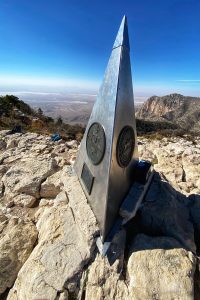
Wiping sweat from my brow, I look up and involuntarily let out a yelp. The top of a silver pyramid is visible overhead – striking against a bluebird sky. It’s the iconic monument marking the summit of Guadalupe Peak – the highest spot in Texas. And it’s less than one switchback away.
Lactic acid courses through my backside like venom as my companion, Michelle, and I make our way up the last fifty yards or so of rocky trail.
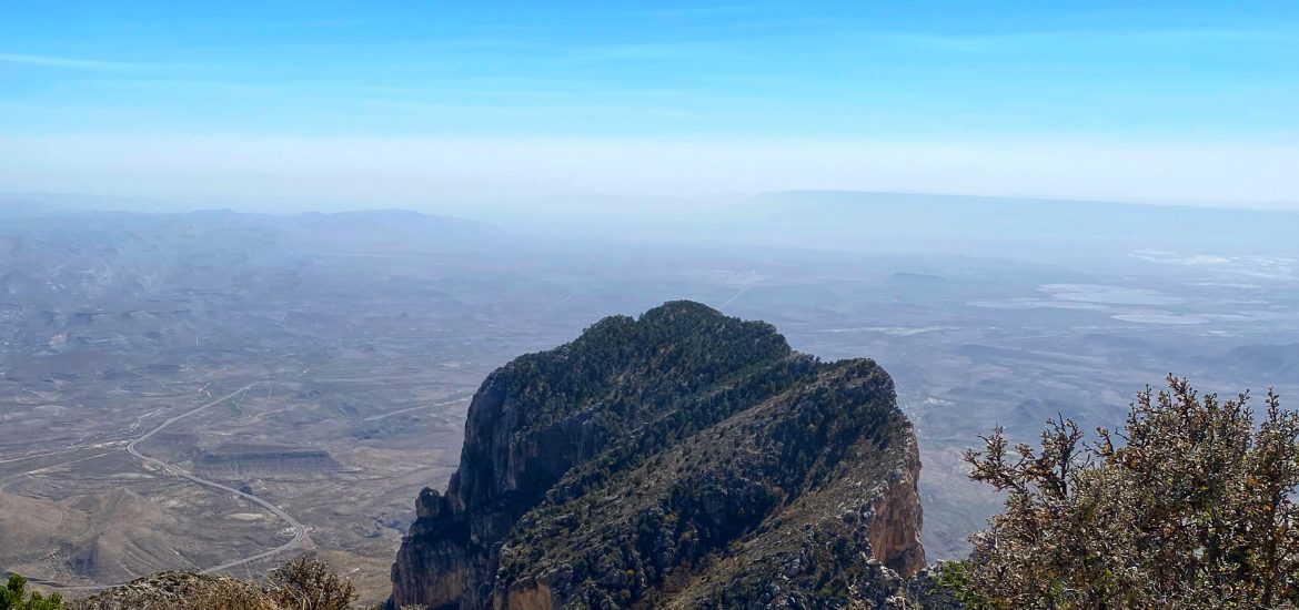
We’re greeted with magnificent 360-degree views. Salt Basin Dunes to the south, a 2,000-acre desert landscape that began forming almost 30 million years ago, shimmers like a mirage in the afternoon sun. To the north is New Mexico. El Capitan, the most famous peak in the park, lies below us.
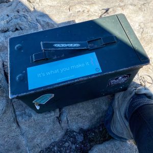
We are not alone; fellow hikers of all shapes and sizes are unfurling flags. Some are removing cardboard signs from their backpacks as they prepare to pose for pictures in front of the gunmetal pyramid, which stands steadfast against the gusty winds. Alongside the structure sits a green army ammo box containing a pen and a notebook. We will all sign our names in it before we begin our descent back down the mountain to the Chihuahuan desert floor.
Guadalupe Mountains National Park is one of the least visited parks in the national park system.
Its remote location, 100 miles southwest of Carlsbad, New Mexico, and 150 miles east of El Paso, Texas, is a big reason. Although not easy to get to, don’t let the location deter you. Far from any semblance of civilization, this nearly 90,000-acre destination is unlike any other park. Home to the world’s most extensive Permian fossil reef, the four highest peaks in Texas, and an incredibly diverse collection of flora and fauna, it definitely deserves a spot on every adventurer’s bucket list.
At the Visitor’s Center, we learn that millions of years of geological transformation formed the Guadalupe Mountain skeleton, while powerful winds and the equally powerful forces of water carved its intricate character.
During the Permian period, some 265 million years ago, a vast sea covered much of the region. Within this sea, calcareous sponges, algae, and other lime-secreting marine organisms, along with lime precipitated from the seawater, built up and formed a reef that paralleled the shoreline for four hundred miles. After this sea evaporated, the reef was buried in thick blankets of sediment and mineral salts and was covered for millions of years until uplift exposed massive portions of it. Today, geologists and scientists come from around the world to study the geologic wonders held here.
Over 80 miles of trails encompass the largest wilderness area in Texas.
There’s something for every skill level, from short-and-sweet nature walks to the strenuous, 8.5-mile trek to the “Top of Texas.” which we have chosen to make. There are even multi-day, backpacking routes for the extremely adventurous through this rugged mountain range, with its deep, sheer-sided canyons, steep slopes, and high ridges.
At the trailhead, a ranger asks us about our plans.
“We’re hiking the peak,” I say excitedly, hoping I’ve hidden the nervousness I feel. 3,000 feet of elevation gain is nothing to scoff at.
Sizing us up, he asks about water. “You’ll each need about three liters,” he instructs. “You’re looking at six to eight hours on the trail.”
After assuring him that we have adequate water, he offers some trail intel.
Several different ecosystems are found within the park – we will pass through three on our hike. These include the harsh Chihuahuan desert community, woodlands of oaks and maples, rocky canyons, and mountaintop forests of pine and fir trees. Together, these ecosystems provide habitat for 60 species of mammals, 289 species of birds, and 55 species of reptiles.
I’m surprised to learn that there are elk here and occasionally a rare black bear. “What about mountain lions?” I inquire casually.
He offers advice for dealing with wildlife while assuring us that an encounter is extremely rare. With a wry grin, he adds, “Don’t worry too much. If you see a mountain lion, he has already decided not to eat you.”
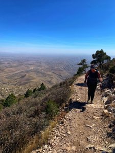
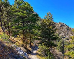
I find his statement equal parts comforting and terrifying as we step onto the trail. Leaving the Pine Springs Trailhead, we begin climbing immediately up the steep slope. We are not alone on this gorgeous Saturday morning. Guadalupe Peak Trail is the most popular trail in the park and heavily trafficked.
Many visitors to the park focus on summiting Guadalupe Peak but don’t overlook the other trails.
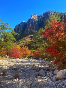
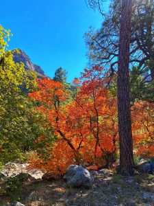
The canyons are not to be missed. Specifically, McKittrick Canyon, considered by many to be the most beautiful spot in Texas.
An extremely scenic hike, the McKittrick Canyon Trail winds up a canyon containing a year-round, spring-fed stream – one of the few reliable water sources in the park. It is especially stunning in fall. The famous bigtooth maples, relics of the last Ice Age some 10,000 years ago, turn fiery shades of red, orange, and yellow for an incredible autumn display. This happens typically in the second half of October and November.
Archaeological finds suggest that the canyon was inhabited over 12,000 years ago. Mescalero Apache lived here until the U.S. Cavalry forced them out in the late 1800s. After that, there was some farming and ranching done in the area. In 1921 a geologist named William Pratt began buying the land. He and his wife lived in the canyon in their home, Pratt Cabin. Eventually, the couple donated the almost 6,000 acres of land they owned to the national park system. That land donation formed the core of Guadalupe Mountains National Park.
Back at the Top of Texas, it’s our turn to pose with the monument marking the 8,751-foot summit.
The iconic structure was erected in 1958 by American Airlines before the area became a National Park. It commemorates the 100th Anniversary of the Butterfield Overland Mail Trail. The route passed south of the mountain, used El Capitan as a landmark, and was the Pony Express precursor. It was disbanded in 1861 due to the inevitable Civil War hostilities.
Strapping our backpacks on, we ready ourselves for the 4.2-mile descent down the mountain. It’s our turn to call out encouragement to the red-faced trekkers we pass, making their way towards the summit.
“Fifteen more minutes,” I say to one weary hiker. “I promise. You’re almost there.”
We go back the way we came, picking our way along the rocky terrain, trying not to pay too much attention to the sheer cliffs – some with over 1,700-foot drops. The trail narrows to little more than two feet wide before giving way to a long series of switchbacks through an Alpine forest. Golden eagles circle overhead, while tall stands of Douglas Fir and Gray tame the strong winds.
Stunning vistas present themselves at each turn of the trail.
I marvel at how different the view is in each direction. Our pace is faster on the way down, but the trekking is still challenging. My toes slam into the front of my boots with every step, and my knees are beginning to talk to me.
The Chihuahuan desert floor looms closer and closer as we come to the spot called “Around the Bend.” Leaving the alpine forest and the worst of the wind, we turn the corner to the southerly facing slope. The parking lot is visible now, albeit far off in the distance. The remaining cars, lined up in surprisingly neat rows, appear to be the same size as my thumbnail from this distance.
The last mile and a half are the steepest.
At this juncture, there is an equestrian trail that can be utilized. It is not as steep, good news for the knees which have stopped talking and are now in full protest, but it adds an extra mile to the route. The sun is disappearing behind the mountain, so we opt to grin and bear it on the shorter section to avoid hiking in the dark.
Back at the car, we high five and click our trekking poles overhead before peeling off our dusty boots and socks. From this vantage point, Guadalupe Peak can not be seen. As the last sliver of the sun slips away, I contemplate the words I scribbled underneath my name in the register—the words of the late Mary Oliver from her poem The Summer Day.
“Tell me, what is it you plan to do with your one wild and precious life?”
![]()
As always, thanks for reading! XOXO
Get updates and information by signing up for my email newsletter.
[ctct form=”1329″ show_title=”false”]
Get started living your own story on the trails and transform your life. Join our Facebook Group here.
Keep up with the adventure with the 52 Weeks 52 Hike Journal. Grab your copy HERE.

![]()


