Tongariro Alpine Crossing – Tongariro National Park, New Zealand
Distance: 13.0 Miles Point to Point
Elevation Gain: 2,789 feet
Rated: Difficult
The bus bumps around a corner onto a gravel road creating great plumes of dust in our wake. Mount Ngauruhoe – you may know it as Mount Doom from the Peter Jackson films – looms in the distance growing closer with each mile.
Looking into the rearview mirror, the driver clears his throat. “When we arrive, I’ll tell you a little about the track before you get underway.” It’s my 29th wedding anniversary, and my husband and I are in New Zealand getting ready to hike the Tongariro Alpine Crossing, considered by many to be the finest day hike in the world.
Grinding to a halt in the crowded car park, the bus stops, and the driver stands.
Running his hand through an unkempt shock of wavy, shoulder-length hair, he surveys the group. Thrusting his hands into his front pockets, he begins speaking. “Well then. The first part of the trek is fairly flat, with a gradual incline. That’s the easy part.” His eyes twinkle, “Next is the Devil’s Staircase – it takes most people about forty-five minutes. The next bit may be windy, but no worries, once you pass the south crater and come around, you’ll be out of the wind then.” His tone rises at the end of his sentences, making them sound like questions.
He suggests a couple of popular lunch spots near the halfway mark and bids us adieu. Collecting our gear, we shuffle single-file toward the exit. “Oh yeah. One more thing.” We stop, awaiting further instruction. “When you descend from Red Crater, it’s easiest to dig in your heels and let your feet slide.” I’m not sure what he means but don’t spend too much time thinking about it as the line moves again.
The Tongariro Alpine Crossing track – New Zealand speak for the trail – is 19.4 kilometers long from point to point.
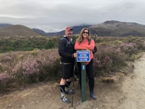
That’s just a little over twelve miles. A few stray clouds roll across the sky, and the air becomes increasingly damp and misty. The scenery reminds me of a Scottish moor. Or, more precisely, what I think a Scottish moor looks like – I’ve never seen one outside of the movies. We continue up the valley following the Mangatepopo Stream and around the edge of an old lava flow.
A drop of water hits my face. More than mist now, a light rain begins to fall. No worries, though. I’m prepared with a rain jacket that I pull out of my pack. A young couple that was on the bus is heading toward us. The woman waves. Her lips are stretched into a tight, thin smile. “We’re turning back,” she calls out. The rain picks up a bit, and now there is a steady stream of bus riders passing us on their way back to the car park.
We arrive at a sign with a life-size cutout of a smiling ranger.
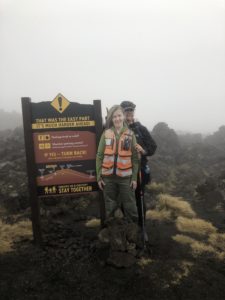
She’s wearing an orange vest over her khaki clothing. To the left of her head is a large exclamation point in a hard yellow diamond. Underneath, it says. That was the easy part. It’s much harder ahead! Underneath, a red text box reads Feeling tired or cold? Weather getting worse? If yes – turn back. Orange, safety-yellow, and red are the universal colors of danger. The mist has given way to thick fog. Visibility is poor. “Should we turn back? Maybe we could try again tomorrow?
Postponing the hike would entail a four-hour drive to our next location after a long day of hiking, and we’re already two hours in. But it may be worth it. After all, I have had an anniversary photo of the two of us poised atop the crater with the blue lakes behind and below us planned for quite some time. The spot is an Instagram favorite. I plan to join the fray by posting it to social media with some pithy remarks about the ups and downs of marriage.
Long story short, I need some clear skies.
Studying the map along the bottom edge of the sign, I wait for an answer.
I already know the answer since the other half of this longish marriage won’t have it. I haven’t told him my photographic plans, mainly because he would find the idea preposterous. Plus, it’s not something I really want to admit. It wouldn’t matter – he’s not the quitting kind and frankly sees the impending weather as a challenge – right up his alley. So up and away we go to conquer the Devil’s Staircase.
A sweaty hour later, we arrive at the top. Lactic acid is coursing through my backside like venom. Visibility is about ten feet, and the temperature has dropped dramatically. Rounding the corner, I’m blasted by a gust of wind that nearly knocks me to my feet. Ahead, there’s another sign. This time it’s a male ranger. He is dressed the same as the female ranger, except he isn’t smiling. One hand on his hip, the other raised with palm forward – the universal sign to stop, his expression grim and faintly disapproving.
The alarming color palette remains the same. The exclamation point is still there, only this time the next line reads Decision Time! The halfway point is Blue Lake, one hour away. There’s a long way to go, and the most difficult and exposed section is ahead.
Shit.
The same questions about feeling tired or cold and the weather are there with a new addition. Is the wind stronger/colder? Clouds coming in?
Yes and yes, sir. Clouds are not coming in. They’re here.
A final warning is emblazoned in red screams, IF YES – TURN BACK! Call your transport provider. MAKE IT HOME SAFE.
“Do you think it will clear up?” I ask the man next to me. He turns to face me, eyes wide as he stares in disbelief. No answer is necessary. “I want to cry,” I pout, pushing my bottom lip forward. “Cry if you must then, but you best keep walking.” He turns, vanishing from view within seconds.
Rain stings my face.
Wiping my eyes, I realize that it’s frozen rain. Or hail. Or snow. I don’t have a clue. I pull my sunglasses down before my eyes freeze like Audrey in Christmas Vacation. They are immediately ripped off my face by the strongest gust of wind yet. I lunge for them as they disappear into the fog, not daring to chase them lest I, too, fall into the volcano and suffer the same fate.
I did mention that we’re walking through an active volcano field, didn’t I?
We press on, stopping for a moment at the sign describing the spectacular views out over the Oturere Valley, Rangipo Desert, Kaimanawa Ranges, and down towards the Emerald Lakes. It’s a good thing there’s a picture because we can’t see squat. And the weather continues to worsen.
My husband offers his hand, and I refuse to take it. I’m irritated at his need always to go hard. Maximum effort. Relentless. The weather is not his fault, but I’m feeling petty. I stomp along the trail, face numb. The force of the wind causes me to stagger like a drunken sailor on leave. Tongariro is derived from the Māori words ‘tonga’ meaning ‘south wind’ and ‘riro’ meaning ‘carried away.’ They weren’t kidding, as apt a name as any.
Eventually, the ground gets soft – not muddy – more like deep sand.
Ahhhh, I think. This is what the driver was talking about this morning. It seems like ages ago.
I tentatively jab my heel into the powdery surface. It slides about six inches. It’s slow going, but I keep at it, sometimes sliding for a couple of feet. There’s a yelp behind me, and I am quickly taken out by a fellow hiker who has decided to slide down. Brushing myself off, I continue.
A crowd has gathered on the right when we reach more level ground.
Squinting, I shuffle closer until I see that it is one of the infamous blue lakes shrouded in gray mist. This was one of the suggested lunch spots, but we opt to continue.
It rains most of the way down. My purple Keens ooze water with every step. “This looks like a good spot for an Orc attack!” The hubs laughs. I giggle too. All I’ve seen of The Lord of the Rings Trilogy is the trailer on the tiny screen embedded in the seat in front of me on the flight over. I’m not sure what an Orc is, but it doesn’t sound good. I would welcome it at this point.
The wind has died down, and the temperatures are rising with each switchback on the descent. Unbelievably, the sun comes out. Now it’s a hot and steamy march through a forest. A wooden bridge appears, and we cross a stream. Suddenly, I remember something the driver said. “When you reach the forest, you’ll cross three bridges. The car park is about four hundred meters past the third bridge.”
Excitement rushes through me. We are wet, tired, sore, and hungry. We cross the third bridge, and I round every turn with anticipation. How long is 400 meters? Why don’t I know the metric system? I think that the 400 meter run in the Olympics is once around the track.
I hope so.
We walk on. Squish. Squish.
At last, we spot asphalt in the distance. The bus only runs once every hour and a half. I think I see it, sitting like a beached whale, parked next to a bank of trees. Filled with hope, I turn. “Is that it? Is that the bus?”
Running is out of the question, and we desperately try to quicken our pace. The thought of waiting another hour and a half is devastating.
Crunching through the gravel, I reach the bus and knock on the door. It opens with a whoosh. “C’mon mate, we’re just leaving then.” We pile in, throwing our soggy packs under the seat before collapsing into it.
The engine rumbles to life. I feel like I’ve experienced so many different emotions. The excitement when we started. Excitement mixed with trepidation. The first leg of the journey was smooth sailing. As obstacles arose, decisions were made together. It was often unclear if the path forward was worth it or if it would be better to throw in the towel. There was disappointment and frustration, but also laughter and exhilaration.
I look at my husband and sigh. “What if the bus left before we got to it?”
“If I had to, I would have thrown myself in front of it. This fucking bus wasn’t leaving without us.”
I lean in for a kiss, spending the rest of the ride propped against his shoulder.
I didn’t get my picture-perfect post or the breathtaking views I’d hoped for.
Yet, I wouldn’t trade it for anything.
![]()
Originally published in Stuff I Wish I Knew Before I Went Hiking: Tales and a Few Fails From the Trail